As you (and others) probably know, SIDs and STARs are established routes that a controller will assign to departing (resp. arriving) aircraft (*). This makes departing and arriving planes not flying into each other and reduces the workload on both pilots and controllers.
(*) There's an exception - SIDs and STARs are not assigned for so-called "VFR flights". I won't discuss them here for simplicity.
In OpenRadar, those procedures - as well as other graphical elements - are stored in one or more .xml files in <OpenRadar directory>/data/routes/<ICAO> where ICAO is the ICAO code of the airport.
In the rest of this post, I will refer to the procedures for LEBL (Barcellona) that were created for one of the previous editions of the Festival.
- Download the OpenRadar file from here, rename it to LEBL.xml and put it in <OpenRadar directory>/data/routes/LEBL.
- Also download aeronautical charts for LEBL (they contain the same information that is encoded in the OpenRadar file, only with more details and in a format suitable for viewing). Most countries make them freely available: in the case of LEBL, you can find them here (get all the PDFs in the SID and STAR sections).
ATC phraseology
While controlling an airport on the FlightGear multiplayer server, (s)he needs to choose the runways in use (the runways which will be used by planes). The general rule is the following one: planes take off and land into the wind, as this makes takeoffs and landings easier for the pilot. There are a couple of exceptions to this:
- in some cases, other factors (like surrounding mountains or noise abatement reasons) limit runway use. Such factors are usually listed in the airport charts. As an exercise, download all the documentation for LEBL from the link I gave you above; one of the charts should contain a paragraph detailing runway use. Try to find it;
- some airplanes (especially big ones, like the Concorde) might require a minimum runway length. If you're dealing with big planes, avoid having them use a short runway.
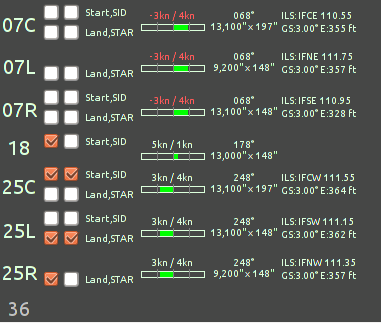
To choose the runways in use, look at the top right part of the OpenRadar window. Under the time/METAR (weather report) you should find the runway manager - some rows, one for each runway, with four checkboxes each:

For each row, the first two checkboxes ("Start / SID") will mark a runway as being used for takeoffs and enable the display of SIDs in OpenRadar; the third and fourth ones ("Land / STAR") will do the same for - respectively - landings and STARs. The image above (taken from the FlightGear wiki and referred to EDDF), for example, shows that:
- runway 18 is being used for takeoffs, but its SIDs are not displayed;
- runway 25C is being used for takeoffs and its SIDs are shown on the screen;
- runway 25L is being used for landings and its STARs are shown on the screen;
- runway 25R is being used for landings, but its STARs are not displayed;
- runways 07C, 07L, 07R, 36 are not being used at the time.
In this case, the ATC correctly chose the runways "heading into the wind" (where the wind component is written in white).
Once the runways are chosen, it's time to assign the appropriate SID to each departing aircraft. The correct SID depends on:
- the departure runway;
- the destination airport (different SIDs lead to different directions).
<Aircraft callsign>, you're cleared to <destination> via the <SID name> departure...
STAR assignments follow the same criteria, except for the fact that they are (obviously!) assigned during the approach and with the following phraseology:
<Aircraft callsign>, cleared for the <STAR name> arrival
(For more details about phraseology, read the ATC Tutorial on the wiki - it has detailed explanations as well as videos with closed captions).
In both cases, to select the SID/STAR in OpenRadar, middle-click on the flight strip for the aircraft in question, then, from the editing box that appears, choose the runway and the SID/STAR.
(I'll discuss creating OpenRadar files tomorrow as it's already quite late).
 [/url]